
CONNECTING COMMUNITIES - VISION FOR THE HARLEM RIVER BRIDGES
Project ID No. X77396
Description
CONNECTING COMMUNITIES: A VISION FOR THE HARLEM RIVER BRIDGES - IMPLEMENT BICYCLE AND PEDESTRIAN FACILITIES IDENTIFIED IN THE HARLEM RIVER BRIDGES PLAN INCLUDING (BUT NOT LIMITED TO) PROTECTED BIKE LANES AND PEDESTRIAN ISLANDS TO IMPROVE SAFETY & ACCESSIBILITY ON: WILLIS AVE (WILLIS AVE BRIDGE TO THE HUB) AND BROADWAY (BROADWAY BRIDGE TO THE NEW PROTECTED BIKE LANES AT VAN CORTLANDT PARK), BRONX (TAP 2019)
Project Overview
Location
This project is located in the NEW YORK CITY region and includes the following:
Counties
BRONX
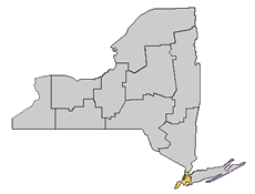
Legislative District:
This project falls within the geographical boundaries of the following legislative districts:
U.S. Senators
Schumer, Charles E.
Gillibrand, Kirsten
Statewide Transportation Improvement Program (STIP)
The Statewide Transportation Improvement Program (STIP) is a list of every project in New York State for which Federal funding is proposed to be used and that is scheduled to begin during the designated three Federal fiscal year time frame. To review the STIP Project List by Region please see the STIP Project Report.
Contact Us:
If you have questions about this project, please contact us:
4740 21st Street, Room 860
Long Island City, NY 10038
Phone: 718-482-4528
Email: rolando.infante@dot.ny.gov