Project Details

NY 36 HORNELL GATEWAY CONNECTION PROJECT (PHASE I)

Project ID No. 609632 , Contract Number D265520

Description

This project will reconstruct 3.0 miles of pavement on NY 36 from Cass Street, in downtown Hornell, to I-86 in the Town of Hornellsville, Steuben County.  Intersection improvements at SR 36 and CR 66 will also provide reduced congestion and increased safety.  New pedestrian facilities from Main Street to CR 70A will also provide increased bicycle and pedestrian access along the corridor.

Project Overview

Project Status

  • The project has been Under Construction.
  • The Bid Opening was on 08/21/2025

Project Schedule

Award of Contract Original Contract Completion Date* Estimated Substantial Completion Date* Construction Schedule Variance from Contract Award**
10/02/2025 11/01/2027 11/01/2027 Schedule Variance Indicator

**Schedule Variance Key:
● Red - Current Schedule Variance is > 10% of Original Completion
● Yellow - Current Schedule Variance is > 5% and <=10% of Original Completion
● Green - Current Schedule Variance is within 5% of Original Completion

Construction Costs

Contract Award Cost Approved Cost Changes Current Construction Contract Cost Cost Variance of Construction Contract**
$36,550,671 $1,553,516 $38,104,187 Cost Variance Indicator

**Cost Variance Key:
● Red - Current Construction Costs are > 10% of Contract Award Cost
● Yellow - Current Construction Costs > 5% and <=10% of Contract Award Cost
● Green - Current Construction Costs are within 5% of Contract Award Cost

This project receives funding from the following sources:

Federal: Yes

State: Yes

Local: No

*Project Schedule Definitions:
Original Contract Completion Date - This is a contractual date,at the time the Contractor is Awarded the contract, representing when the Contractor is obligated to complete all of the work required in the contract and will no longer have a presence within the highway Right-of-Way.

Estimated Substantial Completion Date - This is the day the public (including vehicles and pedestrians) has full and unrestricted use and benefit of the facilities both from the operational and safety standpoint.

Location

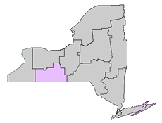
This project is located in the SOUTHERN TIER/CENTRAL NEW YORK region and includes the following:

Counties
STEUBEN

Cities
HORNELL

Towns
HORNELLSVILLE

Villages
NORTH HORNELL

06 Region Map

Legislative District:

This project falls within the geographical boundaries of the following legislative districts:

U.S. Senators
Schumer, Charles E.
Gillibrand, Kirsten

U.S. Congressional District(s)
23th Congressional District (Nicholas Langworthy)

State Senatorial District(s)
58th Senatorial District (Thomas F. O'Mara)

State Assembly District(s)
132th Assembly District (Philip A. Palmesano)

Statewide Transportation Improvement Program (STIP)

The Statewide Transportation Improvement Program (STIP) is a list of every project in New York State for which Federal funding is proposed to be used and that is scheduled to begin during the designated three Federal fiscal year time frame. To review the STIP Project List by Region please see the STIP Project Report.

Community Outreach


PUBLIC MEETING INFORMATION
The New York State Department of Transportation today announced that it will host a public information meeting next week on a proposed project along State Route 36 between Broadway in the City of Hornell, and Webb’s Crossing Road at the following time and location:

WHEN: 6-8 p.m., Tuesday, April 30

WHERE: Hornell Senior High School, 134 Seneca Street, Hornell, NY 14843

The meeting will consist of a presentation of options by NYSDOT engineers in the high school auditorium, followed by an open-house session in the high school cafeteria.
Anyone interested in expressing their views on this proposed project will be given the opportunity to do so in person or through written statements.

No RSVP is required. Should you need any accommodations made for the meeting or would like more information, please contact Route36Corridor@dot.ny.gov.

###

UPDATE: The presentation is viewable below.


Additional Info/Links


State Route 36 Corridor Vision

NYSDOT is considering options regarding a potential transformative project along State Route 36 in the Hornell community, from Cass Street to the southern limit of Arkport.

Nothing has been decided to this point and it is imperative for us to solicit input from the community. Right now, everything we're discussing is conceptual and we fully believe that achieving the best solution engages the community early and often.

This website will be utilized to provide updates regarding the project and answer questions you may have. 

We look forward to collaborating with you on this potential opportunity to enhance our community!

If you were unable to attend our public meeting this past April, you can find the a copy of the presentation that was given available here!

Photos/Visualizations

A birdseye view of Route 36 through the Hornell community.

FAQs

What work has NYSDOT done so far when considering this project?

  • To this point, NYSDOT engineers have only studied the corridor for opportunities to enhance motorist and pedestrian safety. Any potential options or considerations will be conveyed to the public before the project moves forward.

I keep hearing NYSDOT is installing a roundabout along Route 36 with this project. Is that true?

  • The Highway Design Manual utilized by NYSDOT engineers states that the feasability of a roundabout must be analyzed when considering a project such as NYSDOT is along the Route 36 corridor. That being said, all work to this point has been conceptual and a roundabout is not the only alternative being evaluated. Nothing has been decided and will not be decided for some time.

The presentation showed a roundabout at Webbs Crossing Road. Has that been decided?

  • No that has not been decided. NYSDOT engineers have studied various traffic control measures at multiple intersections along the corridor, including roundabouts but, again, all work thus far is conceptual.

I walk/ride my bike along Route 36 frequently. Can we make this corridor safer for other modes of transportation?

  • Enhancing pedestrian and bicyclist safety along the corridor is among the considerations for the project. Pedestrian and bicyclist use has risen since the corridor was first installed and NYSDOT studies show opportunities to better accommodate this multi-modal traffic.

I think Route 36 is fine. Why even consider changes?

  • NYSDOT engineers are always asking themselves: “Is our current transportation network serving the community in a way that best meets the public’s needs?” Given the age of this corridor, how the community has evolved since its installation, and the interests of pedestrians and bicyclists, we are seeking to:
    • Enhance a road and bridge system that will serve the community
    • Improve safety on the corridor
    • Better support the needs of the businesses in our community who need to get goods in and out of the City of Hornell
    • Improve Pedestrian and Bicyclist movement along the corridor

What are the project limits?

  • The limits under consideration go from Cass Street in the City of Hornell to the southern limit of the Village of Arkport.

When will construction start and how long will it last?

  • This project is in its infancy. NYSDOT engineers have only studied conceptual ideas to this point. Any construction wouldn't begin for a few years and it would be much too premature to speculate on that timeline.

The presentation showed a reduction from four lanes to two lanes. Has that been decided?

  • No that has not been decided. NYSDOT engineers have studied how a reduction to a two-lane facility would impact the community and it is something that will continue to be explored. Lane reductions, however, would offer the opportunity to better accommodate pedestrians and bicyclists, both of which have increased since the current design of Route 36 was installed.

Won’t lane reductions just increase congestion along other roadways in our community?

  • The concepts put forward by NYSDOT engineers are designed to accommodate the traffic volumes seen along the corridor, so an increase in congestion elsewhere is not anticipated.

Why doesn’t NYSDOT allow left hand turns into the northern entrance of the plaza?

  • NYSDOT engineers have studied the addition of adding a left hand turn at this location. Estimates show that 30 percent of cars that currently use the southern entrance to the plaza would utilize a northern access if that became available, alleviating congestion along this section of Route 36.

How might these proposed options impact the schools?

  • We are engaged in conversations with the schools and discussing the potential benefits the outlined concepts.

Will street lights be installed as part of this project?

  • The installation of street lights are being considered but will be studied further as the project progresses.

Why can’t we just maintain what we have?

  • As mentioned, NYSDOT engineers have asked themselves “Is our current transportation network serving the community in a way that best meets the public’s needs?” and believe a project offers opportunities to enhance safety and better accommodate the community’s 21st century needs.

I have questions and comments about this project. How can I get in touch with the Department?

  • You can send any questions or comments regarding this project to Route36Corridor@dot.ny.gov!

Contact Us:

If you have questions about this project, please contact us:

Mare Millow
107 Broadway
Hornell, NY 14843
Phone: 585-272-4818
Email: mare.millow@dot.ny.gov
Provide feedback on this project