Alternatives Under Consideration:
Alternative 1: Maintenance or No Build “Null” Alternative
Under this alternative, no improvements would be made and routine preventive maintenance, as well as corrective action within the capabilities of Regional Maintenance forces, would be undertaken. The Null/Maintenance alternative will result in the continued deterioration of the structure and roadway, resulting in further traffic delays, restrictive load postings, continued safety concerns, and eventual closure of the structure. This alternative is being retained for comparison with the preferred build alternative but does not meet the project objectives.
Preferred Alternative 2: Bridge Replacement and Highway Reconstruction
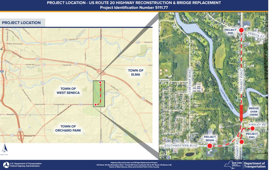
This alternative would completely replace the existing structure with a continuous span, steel multi-girder superstructure with a composite reinforced concrete deck. The total length of the bridge would be approximately 850 feet on conventional cantilever abutments and concrete piers founded on spread footings on rock. This alternative would also include highway reconstruction north of the structure to the Seneca Street intersection and south of the structure to Reserve Road. The full-depth reconstruction north of the bridge would widen the existing corridor to carry two 12’ travel lanes in each direction, a 12’ continuous Two-Way Left Center turn lane, 5’ shoulders, 5’ sidewalks, and a closed drainage system would be provided on both sides of the highway. This section would include the replacement of an 18” unlabeled culvert to current standards at RM 20 5302 1281 and CIN 544017450. The full depth highway reconstruction south of the bridge is required to tie the existing alignment into the shifted alignment for the new structure (alignment is widened to the east). The realigned section south of the bridge would consist of two 11’ travel lanes in each direction, a 12’ continuous Two-Way Left Center turn lane, 8’ shoulders, and an open drainage system. This shift in alignment would introduce a reverse curve on US Route 20 north of the structure to tie into the existing alignment. Culverts CIN 544017013, CIN 544016857, CIN 544017197, and CIN 544021131 are all within the limits of this section of reconstruction and will be reconstructed to be within current standards. Realigning US Route 20 will require modifying the curve on Kinsley Road to accommodate the larger horizontal curve of US Route 20. This realignment on Kinsley Road would require reconstructing the curve near the existing RV dealer to bring it further away from the existing concrete barrier. More information regarding the realignment of Kinsley Road can be found below. This alternative will accommodate a wider typical section to provide adequate traffic capacity, as well as separate pedestrian facilities and bicycle accommodations on the shoulders. See Appendix A for typical sections. Various work zone traffic control options were considered for this alternative, refer to Section 2.7.2 for discussion on the options that were considered. The preliminary construction cost estimate for this alternative is approximately $39.5M. This alternative would constitute an “Adverse Effect” on the existing eligible historic structure. This alternative meets the project purpose and objectives and is the preferred alternative.
Alternatives Found to be Not Reasonable:
Alternative 3: Bridge Replacement on New Horizontal Alignment and Highway Reconstruction
This alternative would include complete removal of the existing structure and construction of a new bridge on a new horizontal alignment to the east of the existing structure. This alternative would also include highway reconstruction north of the structure to the Seneca Street intersection and south of the structure to Reserve Road. The full-depth reconstruction north of the bridge would widen the existing corridor to carry two 12’ travel lanes in each direction, a 12’ continuous Two-Way Left Center turn lane, 5’ shoulders, 5’ sidewalks, and a closed drainage system would be provided on both sides of the highway. This section would also include the replacement of an 18” unlabeled culvert to current standards at RM 20 5302 1281 and CIN 544017450. The full depth highway reconstruction south of the bridge is required to tie the existing alignment into the proposed alignment for the new structure. The realigned section south of the bridge would consist of two 11’ travel lanes in each direction, a 12’ continuous Two-Way Left Center turn lane, 8’ shoulders, and an open drainage system. Culverts CIN 544017013, CIN 544016857, CIN 544017197, and CIN 544021131 are all within the limits of this section of reconstruction and will be reconstructed to be within current standards. This realignment will require constructing a new roadway to connect Kinsley Road to Old Transit Road (NY Route 187). This shift in alignment would also introduce a reverse curve north of the structure to tie into the existing alignment. This alternative will accommodate a wider typical section to provide adequate traffic capacity and would eliminate the need for an offsite detour. This alternative would also provide separate pedestrian facilities and bicycle accommodations on the shoulders. To realign US Route 20, a significant amount of additional right of way acquisitions would be acquired and relocation of seven properties would be required (five residential and two commercial). Additionally, this alternative will have more environmental impacts compared to the preferred alternative, as more previously undisturbed land will be required to realign US Route 20. The preliminary construction cost for this alternative would be approximately $41.9M. This alternative provides the same transportation improvements as alternative 2 at an additional cost of $2.4M, additional environmental impacts, and requires substantially more right-of-way acquisitions. Compared to alternative 2, this alternative requires an additional 2.8 acres in FEE acquisitions, five private property relocations, and two commercial property relocations. This alternative would constitute an “Adverse Effect” on the existing eligible historic structure.
Alternative 4: Bridge Rehabilitation – Deck Replacement
This alternative would include the replacement of the existing deck, overhangs, and traffic barrier. It would also include concrete repairs to the existing arches, spandrel columns, and floorbeams, as well as the replacement of select spandrel columns and floorbeams that exhibit severe deterioration. Continued maintenance would be required on the superstructure and substructure due to continuing deterioration. It is anticipated that the service life of the rehabilitation would be 25 years, at which point the structure would be 120 years old and would need to be replaced. Rehabilitation would not be able to facilitate five lanes of traffic which is required to increase the Level of Service of the highway corridor and maintain the existing center turn lane for the safety of the nearby residences adjacent to the existing structure.
Rehabilitation would also not be able to provide sidewalks, an important aspect of a complete street, and pedestrian traffic would have to be accommodated on the shoulders. Due to the nonredundant nature of the existing structure, staged construction is not feasible and the bridge would need to be closed during construction. This would require an 8.5-mile off-site detour. A traffic analysis of this off-site detour was completed and it showed a poor level of service along the detour without performing significant upgrades to the detour route. These upgrades would require a significant amount of additional right-of-way acquisitions, utility relocations, and environmental impacts. Due to these additional delays, the length of the detour, and the large amount of traffic that the existing structure carries, the residual costs on the traveling public are high. The preliminary construction cost estimate for this alternative is approximately $13.6M. This alternative is expected to constitute a “No Adverse Effect” on the existing eligible historic structure. This alternative was dismissed because it does not meet the project purpose and objectives.
For a more in-depth discussion of the design criteria and nonstandard features for the reasonable alternative(s) under consideration see Section 2.5 of this report.
Kinsley Road Realignment Options
As a result of the preferred alternative, Kinsley Road will need to be realigned. The current road turns sharply around an existing RV retail and repair business coming within close proximity to both Transit/Southwestern Blvd. and the above-mentioned business. The lack of superelevation along Kinsley Road at this location has contributed to a history of roll-over accidents with trucks prompting the installation of barrier between Transit Road and Kinsley Road. The following two options were considered:
Option Under Consideration:
Altered Alignment Option: This realignment for Kinsley maintains a large portion of the existing alignment and would only alter the curved section affected by the shifting of US Route 20. The existing curve would be replaced with two curves and a small tangent section. This design will provide standard pavement and shoulder widths. There will be no physical separation between the realigned roadway and adjacent businesses with the pavement edge 11’ from the edge of the highway boundary and the building corner 9’ away, there will be no impact upon the businesses. All adjustments to the roadway can be accomplished within the existing highway boundary and would result in no easement/property acquisitions and minimal environmental disturbance. A stop condition was investigated for the curve on Kinsley Rd. and was deemed that the situation did not warrant a stop condition and could not be utilized, based on coordination with Regional Traffic and Safety. A connection to US Route 20 was also investigated, however due to the connection being severed in the past due to safety concerns and the proximity to the existing signal at Old Transit, Regional Traffic and Safety deemed this situation to be unacceptable.
Option Found to Be Not Reasonable:
New Alignment Option: This alignment for Kinsley creates a new alignment running through the wooded area to the east of the current alignment. There would be a stop condition at the intersection to the current Kinsley Rd. as well as its southern intersection. Kinsley Rd. would need to be dead ended with possible cul-de-sacs on either side of the current curve. These dead ends would need to still be maintained by the town as they both service businesses. There is significant ROW that would need to be acquired to construct this alignment. There would also be significantly greater construction costs due to the scope of this new alignment.
The Altered Alignment Option is the preferred option due to minimal costs, environmental disturbance, and property acquisitions. This option meets current roadway standards.